We added a state to where we've hiked on the Appalachian Trail this weekend: New Jersey. We took two friends with us, one of whom had never been backpacking before. We intended to do a 14 mile section of the Appalachian Trail from highway 206 to New Jersey Highway 23. It didn't quite go that way, but it did turn out to be a really nice trip.
Saturday, after getting a parking permit from High Point State Park, we dropped one car off at the parking area on NJ 23. Then we drove south to the Stokes State Forest office to get a permit to park at the Sunrise Mountain parking area just off of highway 206. When we arrived, they were randomly closed for most of the day. They also had no apparent self-registration. We drove back over to the parking area to see if there was a self-registration area there. No dice. A woman sitting in the parking area chatted with me for a minute and said they definitely tow from that lot if you don't have a permit. A check of another website confirmed that. She also suggested we check with a nearby local hiker-friendly bar to see if we could leave our car there. That also didn't work and I was pretty frustrated at this point.
After a bit of commiseration, we decided to do an out and back from the first place we parked. Instead of 14 miles, we would hike 6 miles to the shelter where we had planned to stay and then return the same way on Sunday. So, another half hour in the car and another parking permit (after waiting for the office to open after lunch) and we were finally on our way. Phew! Ten minutes down the trail, all frustration was forgotten in the bright, warm sun.
The trail mostly keeps to the ridge top. There were a few steep climbs, but they were short and there were plenty of rocks. There were also several nice views. We took a short detour at the halfway point to get water. The shelter we were headed to doesn't have a water source. We thought we were going to have to hike an extra half mile each way to the spring at Rutherford Shelter, but in less than half that distance, we found a nicely flowing stream.* We took a long break and enjoyed the weather while we filtered water. Hauling a gallon of water each is never fun, but we only had three miles to go to get to Mashipacong Shelter, so it wasn't too bad. A short distance from our water stop, we passed a trail junction. On consultation with the map, our friend suggested that we take that trail (the Iris Trail) back to the car the next day, making a loop instead of an out and back.
We spent a very pleasant night eating dinner and playing cards. One nice thing about Mashipacong Shelter: They have a bear box there (basically a large steel locker), so we didn't have to hang our food. The next day we headed back the way we came and turned onto the Iris Trail when we reached that intersection. It was a great decision. The trail passed by interesting wetlands, old stone walls and house foundations, and a beautiful lake.
We all (I hope!) had a great time. Adaptation was key to this trip and everyone played a part in making it work. It was also beautiful. We are now discussing a longer trip on the New Jersey Appalachian Trail later this year.
*For anyone researching this section of the trail, I suspect it is a seasonal stream and unreliable later in the summer).
Hiking up one of the steep, rocky sections of the trail.
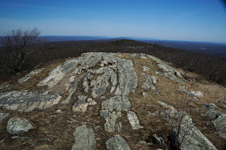
The view to the east, into New Jersey, from one of the rocky outcrops on the trail.
We passed several of these boggy spots. They are probably ephemeral. They were also full of salamanders, which was pretty cool.
Moss near the boggy spot above.
The little stream where we got water.
Taking a break while waiting for the water filter to do its job.
A sign for the Appalachian Trail.
Our friend and Michael blowing up sleeping pads
Sunset from behind the shelter.
The Iris Trail, covered in moss and grass. This trail clearly doesn't get as much use as the Appalachian Trail.
Epigaea repens (Trailing Arbutus). This isn't a great picture, but I'm still learning about my new camera.
Rutherford Lake from the Iris Trail
Thalictrum thalictroides (Rue Anemone)
After we finished our hike, we drove up to High Point, which is the aptly named, highest point in New Jersey. This is looking north from the base of the monument.
The monument at High Point. One of our friends said she remembers being able to climb the stairs inside up to the top when she was in elementary school. Unfortunately, they don't allow you to do that anymore.


No comments:
Post a Comment