Sunday, April 3, 2022

Overall Run -Heiskell Hollow: Spring is Coming

 We returned to Overall Run to do a long hike today. This hike was the first place we had hiked, other than Old Rag, with our friend that we lost last year. Lots of memories today. We started at Thompson Hollow trailhead on the boundary of the park and hiked the quick mile to the Overall Run Trail. It was nice and warm (in the 50s), but we could hear the wind roaring above us. We were surprised, when we got Overall Run, to see how low the creek is for April. We haven't gotten much rain this spring and the creeks show it. 

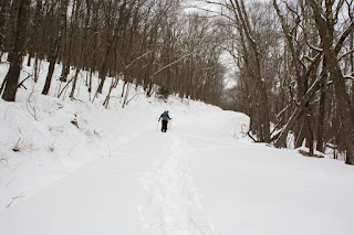
From there, we turned left and began the hike up to Overall Run Falls. In the first mile, we passed through lots of new spring flowers: Bloodroot, Cut-leaf Toothwort, Dutchman's Breeches, and Hepatica. We also heard our first Louisiana Waterthrushes of the year. After about a mile, the trail turns away from the creek and begins one of the steeper climbs in Shenandoah National Park. The mile up to the falls is definitely character building. It has switchbacks now and it is still steep, but the switchbacks criss-cross the old trail, which was basically straight up the mountain. There was more water in the falls than I expected, but not as much as should be for this time of year. The wind at the falls was a force to be reckoned with. Strong gusts of freezing cold blasts kept us from lingering there for more than a couple of minutes. It was definitely still winter up there. No signs of spring vegetation or buds on trees to be seen.

From the falls, we continued up another mile to the junction with the Weedlewood Trail. Almost immediately, we found a nice log that was out of the wind for lunch. The Weedlewood Trail is a very pleasant horse trail that winds down the mountain, eventually connecting with the Heiskell Hollow Trail. The Heiskell Hollow took us back down to the valley and into early spring, with wildflowers reappearing along the trail. We took the Overall Run Connector and then the Overall Run Trail back to where we started. It was a really nice day on trail. We saw one group of four people and one group of two then entire day, which was pretty nice for a trail that can be fairly busy.

Pictures:

Bloodroot
Rue Anemone
Dutchman's Breeches
The view from the top of Overall Run Falls looking west. 
The Weedlewood Trail


Sunday, March 13, 2022

Signal Knob the Day After A Spring Snowstorm

 Yesterday, we had a spring storm that started out with gross, cold rain. It quickly changed over to snow. It didn't amount to much in the DC area and, even in the mountains, it wasn't expected to be more than a couple of inches. That meant snowshoeing was out. This weekend is also time change, which meant that we would have to drag ourselves out of bed earlier than usual, too. We ultimately decided to do a hike we hadn't done in several years: Signal Knob. The hike starts in a large parking lot that often fills near Elizabeth Furnace in the Massanutten area. 

When we pulled in, there was one other car in the parking lot. Not a bad start. It was 16 degrees with the promise of temperatures rising to near 40. The trail was covered with an inch or two of snow and the steady climb was a welcome way to warm cold fingers. There were a few tracks on the trail, which ended at the first campsite. Someone had clearly been up either camping or just enjoying a campfire the night before. It would have been chilly night to be out! After that, we were the first people on the trail today. We saw and heard our first Pine Warblers of the year, which was a welcome sign that spring is coming! 

At Signal Knob, we found a relatively sheltered spot to eat some lunch. There was more of a breeze that was ideal and it was still pretty cold. At this point, we were kind of marveling that we hadn't seen anyone so far. When we've done this hike, in the past, we've backtracked from Signal Knob to the Meneka Peak Trail and hiked south on that to catch the Tuscarora. This time, we decided to continue on the Massanutten Trail and connect with the Tuscarora in the valley below to the west. While this meant an extra climb, the distance was the same and it kept us out of the wind on the ridge. The hike down to the Tuscarora Trail went quickly on the road. From there it is steep climb back up to the top of the ridge. We quickly shed the layers we had put on at lunch.

From the junction with the Meneka Peak Trail back to the car is four winding miles. By this time, most of the snow had melted off of the trail and there were definitely some muddy patches. It was a pleasant walk down, though and we saw no one until we reached the parking lot. It was a really good day. All said and done, 10 miles.

The view northwest from Signal Knob
Leaves frozen into the ice on the Massanutten Trail near the junction with the Tuscarora
A relatively poor photo of a lenticular cloud west of us. I forgot the battery for my good camera, so all I had was my cell phone.
Bird tracks in the snow
The Tuscarora Trail below Meneka Peak
Perfect blue sky
A bird nest from last year. It looks like it might be a Red-Eye Vireo nest.


Monday, February 21, 2022

Sky Meadows State Park

 Michael had a date with some friends to go rappelling yesterday, so I decided to go out for a hike on my own at Sky Meadows State Park, which is near the sprawling metropolis of Paris, Virginia. We hiked through Sky Meadows once, many years ago, with our late friend, Anne. That day was frozen solid. Yesterday was quite a bit warmer, if still a bit chilly. It was 24 degrees when I started up the South Ridge Trail and the ground was, thankfully, frozen. The trail had obviously turned into a mud pit the day before. The climb wasn't bad and I had the trail to myself. I stopped now and then to look at birds. 

I reached the Appalachian Trail and turned north. It was as pretty as I remembered up there, with the open meadows and views to the east. Although it was bright and sunny, the wind made it pretty cold up on the ridgeline. I started to see more people once I headed down the Ambassador Trail. The trail also had melted a bit and was quickly turning to mud. I stopped for a few minutes at the Piedmont Overlook. There is a nice bench there and I thought about eating lunch, but it was still too windy and cold there. In retrospect, I wish I had eaten there. The trail got more and more crowded and noisy as I descended through the woods. I finally found a log to sit on to eat and watch the non-stop stream of people sliding down the hill of the Piedmont Trail. I did enjoy the descent down the other side of the Piedmont Trail. The view can't be beat and the trail is really pretty. I will say I was glad to be going down it vs. ascending it. The South Ridge Trail is definitely less steep. 

Once I was down the in the valley again, I took the Hardow Trail, which runs along a pretty little creek. It was still pretty muddy, but it was quiet. On my way back to the car, I ran into a couple out birding who nicely pointed out a Red-Headed Woodpecker, which was my first of the year. All said and done, it was a nice 8 mile day with some solid climbing. 

Definitely get to Sky Meadows early if you want to avoid the crowds.

An Eastern Meadowlark in the parking area first thing in the morning.
The view from one of the meadows 
Hiking through a meadow on the Appalachian Trail
Last season's dried flower stalks
Hiking down the Piedmont Trail


Saturday, February 12, 2022

Hike to Emerald Pond

 We did the Emerald Pond hike in the Massanutten area today. It is a little over 8 miles and is a lollipop, so there is a little loop at the end, but there's some out-and-back as well. The hike starts from the abandoned Massanutten Visitor Center on Highway 211. I couldn't find any reference online as to when it closed. There is an article in the Washington Post from 1989 that references it being open, but other than that, there is little information on it. 

In any case, after a short descent, the trail climbs steeply for a bit more than a mile to a really nice overlook of the Shenandoah Valley to the west. We took a brief break there and then continued south on the Bird Knob/Massanutten Trail. From the overlook, there is probably another two miles of very gentle climbing and then a slow descent towards Bird Knob. About a mile after the overlook, the Massanutten Trail splits off to the left. We stayed on the Bird Knob Trail. The trail passed through lots of pine groves and mountain laurel, nice and green in the middle of winter. We came out into a meadow with a tiny frozen pond at the end of the Bird Knob Trail. From there, we descended to Emerald pond, which is, indeed, clear and and green. After a bit of confusion about which way to go, we headed up the hill to the Massanutten Trail, which follows a forest road for a few miles. We passed a lot of large Allegheny Mound Ant mounds, but I neglected to take pictures of them. At the junction with Bird Knob, we retraced our steps to the car.

A White Breasted Nuthatch near the overlook. 
The Shenandoah Valley from the Overlook
The tiny frozen pond
Emerald Pond
The overlook on our way down.


Sunday, January 30, 2022

Snowshoeing and Some Thoughts on visiting Dolly Sods in Winter

 I'm going to give this blogging thing a try again. It has been a couple of years...quite a couple of years. But here I am and I'm still outside. I just haven't been writing as much about it. I have been posting on instagram, so it is worth checking that out, too.

We snowshoed up into Dolly Sods today with a friend. We started at the gate on the north side of Forest Road (FR) 75.* There were a couple of inches of snow where we parked. It quickly became 6 inches as we walked up the road. Then after the first mile, it was more like 12 inches. It kept getting deeper all the way up the road until the very top of the plateau. Just below Bear Rocks, the snow was suddenly gone, having been scoured away by the constant wind up there. Wherever there was shelter, there were snow drifts. We made the three miles uphill to Bear Rocks in decent time. Then we spent some time at the cliffs on top of the plateau. It was a pretty magical, perfect weather day:  temperatures in the low 20s and little wind. We had originally intended to hike yesterday, but our friend had a conflict. That turned out to be a good thing: yesterday, the high was about 10 degrees and the winds were gusting over 50 mph. 

We only saw one group the entire day: a group of six that were woefully underprepared for the night they had just spent out. They were in good spirits, at least, and headed out, so they were going to be fine. 

*So, a few thoughts about visiting Dolly Sods in winter because we've encountered a few groups that seemed surprised by these things over the past few years. 

  • Unless you are staying in Old Timberline, there is no way reliable way to drive up to Dolly Sods in winter. The US Forest Service gates both FR 75 and FR19. I don't think FR 80 is gated, but it also isn't plowed. At all. This means that however you go, you will have a long approach walk. It is three miles from where we parked today to Bear Rocks, on the eastern edge of the plateau. It is all uphill to get up there. It isn't super steep, but it is a steady climb. FR 75 absolutely needed an AWD vehicle today just to get to the gate. I've seen several parties pull up to the gate there completely surprised that they couldn't drive up. 
  • Weather: The weather can be really harsh up there. If it is breezy and chilly down in the valley, or where you live, you can bet it is gale force winds and frozen up in Dolly Sods. We were up on the west side of Dolly Sods two weeks ago and it was so windy that it was difficult to stand. I've also been lucky enough to be up there when it is cold but there is little wind. Those days are pretty magical. If it has been warm, it will be a muddy mess up there in the winter. My point of all of this? Hiking in Dolly Sods in winter requires you to be prepared for harsh conditions. 
Pictures:
Michael Snowshoeing up the road
Michael and our friend working their way up the road
Wind scour lines in a snow drift
Looking east from Bear Rocks
Looking out over the valley to the east
Michael near Bear Rocks
North Fork Mountain in the distance
Flagged trees near Bear Rocks
Flagged trees near Bear Rocks.

Sunday, March 15, 2020

Middle Creek WMA: Snow Geese and Frogs

A number of years ago now, we visited Middle Creek Wildlife Management Area, near Lancaster, Pennsylvania to see the Snow Geese Migration. We've always talked of going back, but it just hadn't worked out until last weekend. There weren't as many geese this time and there were only a few Tundra Swans, but we were also a little bit later in the season. Peak migration was a few weeks ago. In spite of that, we still had a great day and saw lots of birds:

 Snow Geese coming in for a landing
 Hanging out on shore
 Something spooked them and a whole bunch of them took off from the water at once. The sound of all of their wings beating was impressive.
 Graceful landing
 Another one coming in to land.
 All lined up
 Even though there were fewer geese than the last time we were there, there were still a lot of geese.
I was trying to take pictures of Tundra Swans that were really too far away to photograph, when this little Belted Kingfisher got my attention. It was a noisy little thing, but was happy to sit there and let me take pictures (click to enlarge).
 Two ducks feeding on the lake.
 Snow geese moving en masse
 We drove the road around the WMA, which took us by a little wet spot that was full of Wood Frogs and their egg masses. The frogs themselves were really vocal and love was in the air. You can hear a brief recording of their calls here (scroll down on the right)
 A couple of frogs on the egg masses.
 Snow geese on the water later in the day.
A juvenile Bald Eagle.

Tuesday, March 10, 2020

Washington State: Hiking and Snowshoeing

I had to go to the Seattle area for work last week. We have friends who live south of the city, so I went out early and got some hiking in. We started with Lena Lake in Olympic National Forest on Saturday. The forecast was pretty typical for March in the Pacific Northwest, so I was prepared to hike all afternoon in the rain. Having all of my rain gear with me resulted in a beautiful, mostly sunny afternoon. You can't beat that. I also credit the forecast for keeping the crowds away. We saw very few people on a trail that, according to my friend, is pretty popular.
 A cool, bent tree along the trail.
 An orange slime mold.
 The night before, it had rained pretty hard at my friends' place. It had clearly snowed higher up.
 An impressive bridge on the trail.
 Reaching the snowline
 A waterfall on a small creek.
 A sign pointing us towards the lake.
 Lena Lake.
 On the way home we stopped for dinner. The sunset over Hood Canal was spectacular.

On Sunday, we went snowshoeing at White Pass Ski Area. The nordic center has cross-country ski and snowshoe trails.
 Starting out around a little lake.
 Michael's snowshoes pack flatter than mine in a suitcase, so I took his with me. Now his snowshoes have hiked in Washington.
 The trail took us back to a little waterfall, where we had lunch.
 This Canada Jay tried to convince me to give up my snack bag. Nice try, little guy.
 This is where old trekking and ski poles find a new life. Most of the snowshoeing trail markers were held up by old poles.
 Heading back to the start.
Looking back on the lake near where we started.