Saturday, Michael and I finally got out after what seemed like months of rain only on the weekends (ok, maybe a month of rainy weekends). I don't mind hiking in the rain in the summer, but I'm not a big fan of cold rain. We intended to do the Stricklers Knob-Duncan Knob loop, which is about 10 miles. Michael had never done it before and it has been a number of years since I've been on those trails. We arrived to find the road gated about three miles before the Scothorn trailhead. We talked for a few minutes about driving to Kennedy Peak, but we weren't really interested in spending more time in the car. After consulting the map, we could walk up the road 3/4 of a mile and pick up the Massanutten Trail. From there, we would be able to hike to Stricklers Knob. Once there, we could decide whether to return the way we came or hike straight down the mountain and walk back on the road.

The trail started out with a pretty walk along the ridgetop. Once we turned a corner, we could see Strickler's Knob and it was
right there across the hollow beside us below. Unfortunately, we had to descend very steeply all the way down to the bottom of that valley and then hike back up it before we would get there. All the way down into the valley we listened to someone's hunting dogs baying.
A campsite on the Massanutten Trail at the bottom of the valley.
Four miles later, we made it to Scothorn Gap and were well on our way to Stricklers Knob. The trail passes through a fire scar.
The trail out to Stricklers Knob turns into a rock scramble for the last two hundred yards or so. A pair of black vultures were fairly annoyed to be disturbed by us. They would flap their wings and fly a few yards away, only to land directly in the next spot we were hiking to.
A closer view of one of the vultures (I have a decent zoom lens). They finally flew off and we proceeded out to the knob.
The view east from Stricklers Knob.
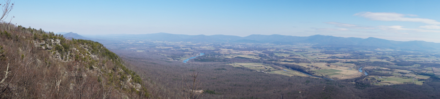
There is another cliff just northeast of Stricklers Knob that actually has a bit better view. I took this panorama from there. That is the Shenandoah River in middle of the photo.
The cairn marking the path out to Stricklers Knob. At this point, we decided we didn't need to see the bottom of that valley again, so we hiked down the Scothorn Gap Trail to the road.
We had a pleasant three mile road walk back to the car.
The temperature was nearly 50 degrees, which was a nice change from our string of rainy, cold weekends.