Wednesday, May 28, 2014

Utah Part 6: The Cycling Tour

This is my last post from our Utah trip and then it will be back to the humidity of the Mid-Atlantic and our garden. The original purpose of the trip was a week-long cycling tour in southern Utah, ~440 miles and 30,000 feet of climbing. We signed up before Christmas and had been training all winter, through all of the snow and cold this year. Although we were prepared, it didn't quite go as planned for any of the three of us.
We started in Zion National Park with a shakedown ride. The three of us were on rented bicycles, so the ride served the purpose of testing out the fit. It was a nice ride. The only vehicles allowed in the inner canyon are the shuttle buses, so there really isn't much traffic at all. The slightly weird thing, although not a big deal once we got used to it, is that bicycles are required to pull over and stop when a bus passes.
Day 2 started out with a nice, long climb up and out of the east side of the park. We rode the up to the tunnel, where we were shuttled to the other side. Then came the long ride with the eventual goal of reaching Bryce Canyon National Park. All said and done, it was supposed to be 89 miles and 6,000 feet of climbing. The day began well and we felt good going into the first break. Then we turned north on US Highway 89 and headed straight into the wind. By the time we reached the lunch stop, Michael indicated that he wasn't feeling great. He wanted to continue and we made it 10 more miles before he decided he wasn't feeling well enough to ride. We rode in the van for the next 25 miles to the next rest stop. At that point, he seemed to be doing a bit better, so I decided to ride the last 17 into Bryce.
When I took off, I was by myself and it snow flurries fell intermittently. I was riding a bike path that followed the highway through Red Canyon and it was just stunningly beautiful. There were a few snowy patches across the path that added some excitement, but overall, I was having a great time. Then the path ended and the snow picked up.
I passed a group of four or five pronghorn antelope along the side of the road.
And then, just like that, I was biking in a blizzard with just a windshirt for a jacket, along a highway. This went on for a bit and I decided I wanted a ride from the van. I waited a little while until I got too cold and then decided to keep pedaling. When the van passed, there was some miscommunication and they kept going, so I rode all the way into Bryce. It didn't turn out too badly. A few miles later, the sun came out again and it was a bit warmer. Still, I was pretty happy to see the sign for the lodge.

In the meantime, Michael was doing worse. The next day, he opted to just ride in the van. We crossed our fingers and hoped it was just food poisoning (i.e. not contagious).
We started day 3 with a short hike at Bryce, mostly to let it warm up a bit before we started riding (it was 19 degrees when I went to breakfast).
Below the rim at Bryce Canyon.
The first 10 miles or so of the ride were a beautiful, winding descent. This is looking back up towards Bryce Canyon.
This was the view near Canonville, Utah. Day 3's route took us to Escalante, Utah and was a nice, pretty ride.
Day 4 started out so well. Michael was riding again. There was a nice, gentle climb for several miles before an epic descent. There are cyclists on the road in this picture (click to enlarge).
We biked through the Escalante River Canyon and then climbed out of it. This is the view from the top. Some of the grades on that ascent were close to 16%.
This was the rest stop at the summit. When we pulled in, I was starting to go downhill. I had been climbing really strong to that point, but I was starting to lose energy. At this stop, I should have been ravenous, but I had to force myself to eat a bit. Then, when we took off, I didn't have much energy to put into the climbs. By the time we reached Boulder, Utah, I was done. I wound up in the van for the rest of the day and had a very bad night in the hotel.
I'm sure Capitol Reef National Park is beautiful, but this view from our hotel room is most of what I saw of it. I rode in the van on days 5 and 6. I didn't have the strength to ride. Michael also rode in the van on day 6 because he overdid it a bit on day 5. I did get some good pictures, though.
Michael leading a paceline on day 5 on the way to Lake Powell.
The Henry Mountains on the way to Lake Powell.
Sunset near Lake Powell.
Sphaeralcea ambigua (Globemallow) along the Burr Trail on Day 6.
Finally, on day 7, I was able to ride a bit again. Back in Bryce Canyon National Park, we rode the only road through the park, stopping at overlooks and sightseeing along the way. Cycling is such a great way to see the parks.
Horseback riders on one of the trails below the rim at Bryce Canyon.
Another view of Bryce Canyon. We only rode about 15 miles, which was enough, given the altitude and recent illness. Overall, the riding that Michael and I were able to do was great. It is just too bad we weren't healthy for the whole week. There were a myriad of ways it could have been worse, though, so on the whole, it was still a pretty good week.


Monday, May 26, 2014

Utah Part 5: Canyoneering and the Narrows

I mentioned in my last post that we were originally supposed to do a canyoneering trip the day we hiked Angel's Landing. Because of the rain, the guiding company strongly suggested that we switch days. Fortunately, both we and their guides had the flexibility to reschedule. Paragon Adventure's (I didn't receive anything for this post - in fact, I paid them. I was just happy with the trip) guides picked us up from the Watchman Campground in Zion National Park early in the morning, and we were on our way to a small canyon called Birch Hollow. We started with a quick hike down to the first rappel. The anchors were already in place, which is the first time I've seen that (admittedly, I have limited experience with canyoneering). Not having to build anchors at each rappel did save quite a bit of time.
This was one of the longer rappels we did. If I recall, our guide said it was about 100 feet. Our friend is belaying Michael as he starts his descent. The walls on this one were almost perfectly smooth.
Michael took this picture of me on one of the last rappels. I lost count of how many we did.
After reaching the mouth of Birch Hollow, we hiked down Orderville Canyon to a small slot canyon . We hiked up it, scrambling over a few boulders and log jams along the way. Eventually, we reached a waterfall that we couldn't scramble up. We returned to our packs and had lunch before hiking up Orderville canyon to the truck. As a bonus, we got a four wheel drive adventure on the way out. The canyoneering trip was awesome and I wouldn't hesitate to recommend our guiding company.

The following day, we hiked the Narrows, which was another life list hike for me. As an added bonus, there is a bit of history there for me. Fifteen years ago, a friend and I drove up to southern Utah from Flagstaff, Arizona to explore some of the slot canyons in the newly designated Grand-Staircase Escalante National Monument. We had no idea what we were doing, but we managed to see quite a bit and not get ourselves killed. We visited Bryce Canyon National Park on the way back and had a conversation about how the next time we were up that way, we needed to go to Zion and hike the Narrows. It only took fifteen years for the two of us to get back there. When I was making plans for the trip, I let her know we'd be out there. She and her family drove up to Zion from Phoenix and we spent three days catching up (It had been six years since the last time we'd seen each other). And we hiked the Narrows, finally.

We took the shuttle bus to the end of the road in Zion Canyon and then hiked the mile to the start of the Narrows with what seemed like the entire population of Utah. The Narrows, at least if you hike it from the bottom, is definitely not the place to seek solitude. At the beach where the trail ended, we changed into neoprene socks and old tennis shoes, rolled up our pants, and marched into the water. It was cold, but I was expecting a lot worse. Once my feet warmed up the water in my socks, it got a lot better.
The hike is largely in the river. In a few places there were large sandbars with a trail, but most of the time, we were knee deep in the Virgin River.
As we hiked upstream, the walls rose around us. Michael is in the middle of this one for scale. It is somewhat unusual to be able to hike the Narrows this early in the season, but southern Utah received very little snow this past winter. That was good for us - the river was hike-able, but it will be bad for fire season there. Even with the low river levels, the current was not insignificant. Hiking poles made a huge difference. So did wearing closed-toe shoes instead of sandals.
After a couple of hours of hiking, we reached a sandbar that lent itself to being a good lunch spot. We shared it with about a million other people, but it was still pleasant. This raven was waiting for people to drop food.
 After lunch, we continued upstream. Many people, apparently, turned around at the sandbar, because the crowds thinned considerably. Michael and our two friends in one of the narrower sections.
 More awesome canyon walls.
Michael and one of our friends in a slow, sandy pool.
Just before we decided to turn around, we reached a deeper pool that we couldn't avoid. Up to that point, the water had been just a couple inches over my knees at the deepest. This pool was up to my hips. Fortunately, the current was really slow here. Michael is carrying my pack through the pool so it won't get wet. Soon after this point, we realized we needed to turn around to make sure we didn't miss the last shuttle back to the campground. It had taken us quite a while to hike as far as we did and we weren't sure that we would be any faster on the way back. It turns out, if you aren't taking pictures around every bend in the river, you can hike quite a bit faster! We made it out in about half the time that it took us to hike in. It was an awesome hike. Maybe one of these days, we'll do the full overnight backpacking trip from the top of the canyon, but the dayhike from the bottom was spectacular.
Aquilegia formosa (Western Columbine) growing on the canyon wall near the trailhead.
 We made it back to the shuttle stop with time to spare and this little hummingbird greeted us at our campsite.

Saturday, May 24, 2014

Utah Part 4: Angel's Landing

Angel's Landing is another hike that was on my life list. It was worth it. Of all of the awesome hikes we did on the trip, this was hands down my favorite. It is only five miles round trip, although the way we hiked it (from Emerald Pools), it was closer to eight, which still isn't epic in length. What it lacks in length, it makes up in sheer awesome. It is what Old Rag wants to be when it grows up. The trail on Old Rag is designed so there is almost never more than 10 or 15 feet of exposure. Angel's Landing multiplies that by two orders of magnitude.

The day we hiked it, we were originally supposed to do a guided canyoneering trip. The weather in the morning was pretty rainy, so we rescheduled, got some coffee and contemplated our options. We decided to check out Emerald Pools in the morning, figuring that rainy weather was a good time to check out a waterfall.
Cairns on the way up to Upper Emerald Pool. The weather kept a lot of people inside, so we actually had Upper Emerald Pool to ourselves.
A viscous mugger attack squirrel at Upper Emerald Pool. I set my pack down for a minute and, as soon as I turned my back, it made a break for it. I'm guessing it was hoping for a granola bar. No luck.
By the time we reached Upper Emerald Pool, the weather cleared somewhat and we realized we were only a mile from the Angel's Landing trailhead at the Grottoes via the West Rim Trail. Rather than retracing our steps and riding the bus for a mile, we just walked.
 We were rewarded with more flowers. Penstemon palmeri (Palmer's Penstemon).
We stopped at the Grottoes for a quick lunch and then began the hike to Angel's Landing. As soon as we crossed the river, we began to climb. This is looking down on the lower switchbacks.
 Castilleja chromosa (Common Paintbrush). These appeared to be growing out of the rock itself. They apparently only need a dusting of soil.
After climbing up a series of 21 switchbacks known as "Walter's Wiggles" (after the man who designed them), we reached the saddle where the trail to Angel's Landing splits off from the West Rim Trail. That's where things got interesting.
The trail goes up and up and up and it was about as steep as anything I've climbed before. There are a series of cables to help hikers. There were occasionally shallow steps as well, which can be seen here, too. We were fortunate again. The weather kept some of the crowds away. While there were definitely a lot of people, it was nothing like what I've read about. We were by ourselves occasionally. We had to wait out a rain squall on the way up, which made the cables wet and cold. Waiting out the rain was actually the only time I got a little anxious, but it was because I was watching other people slip and slide around. I was worried I was going to see one of them slide off into the abyss.
 The last push for the summit. It is probably steeper than it looks.
 Bootshot from the summit looking up the canyon towards the Narrows. The light kept changing because of the unstable weather, so I must have taken about 50 pictures looking this direction from the summit.
 Another beggar on the summit.
 Looking down Zion Canyon from the summit, towards the visitor center.
 Looking down on the road and one of the shuttle stops from the summit.
 On the way down. The cables give a sense of how steep the trail is.
 Another rain squall blew through while we were on the way down.
After it cleared at the sun came out, I came around a corner to find a rainbow in the valley below us! How cool is that. It is actually a double, which can just barely be seen. The second rainbow is above the first. As I said in the first paragraph, this was definitely my favorite hike of the trip (out of a bunch of very good hikes). The view from the top was incredible and the rainbow...well, amazing.

Friday, May 23, 2014

Utah Part 3: Toadstools and Our First Pass Through Zion National Park

Since we had to drive back to St. George, Utah on Day 3, we planned a short hike for the morning and then planned to drive back through Zion National Park. We packed up in the morning and then drove over to the trailhead for the Toadstools, a 1.5 mile out and back just north of U.S. Highway 89. We figured it would be a quick out and back. Like the other hikes out we'd done out there, it wound up taking us quite a bit longer than planned, but that was because it was so cool. We spent a lot of time just meandering and exploring. 
The trailhead is right on the highway. When we arrived, we were the only ones there. We followed the trail though the was up to the first toadstool. 
The trail up to the first toadstool was plainly obvious, but then it split into lots of social trails. It appeared to us that it continued in the wash, so we followed that until it was apparent that we needed to backtrack. Once back at the first toadstool, we quickly found the right trail.
The path took us up to a broad red sandstone bench with toadstools and huge white cliffs.
Around the next corner, we found this overlook, which just begged for a bootshot.
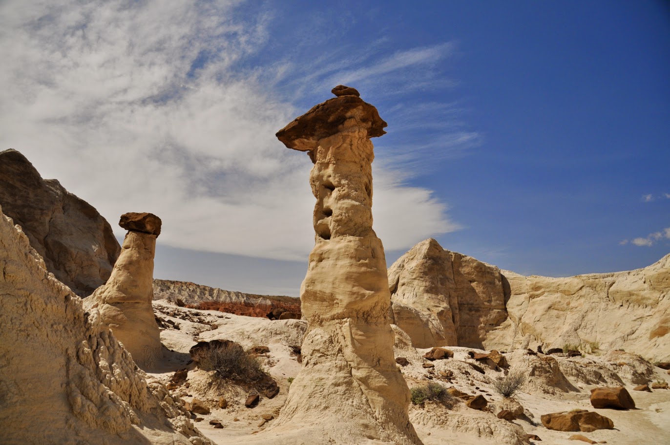
Back in an alcove, we found a bunch of white toadstools. This one was probably ten feet tall. The resistant caprock keeps the column, made of softer rock, from eroding away. More about how hoodoos and toadstools are formed can be found here.
Looking back towards the first set of toadstools.
Another red toadstool.
Calochortus nuttallii (Sego Lily). This is the Utah state flower. As with the other hikes we'd done, the flowers were fantastic.
 Oenothera caespitosa (Dwarf Evening Primrose)
Wildflowers near the toadstools.
 On our way back to St. George, we stopped along the road to the Paria townsite. We didn't make it all the way down there, but we made it far enough to see some amazing views.
Then, after three days of quiet, uncrowded trails, we headed to Zion National Park. You can certainly escape the crowds in Zion by hiking a few miles into the backcountry, but there is no escaping them on the road. This is in the east part of the park. In spite of the crowds, the scenery is spectacular and worth it. On this afternoon, we were just passing through.
Our first look at the Zion Canyon.