I have been hiking and volunteering on Old Rag for almost ten years. I often say, especially after the years with Old Rag Mountain Stewards, that nothing at all could surprise me up there. Yesterday, the mountain proved that it still had a few tricks up its sleeve.
Most of the day, we hiked in dreary, overcast fog. After doing some training at the Byrd's Nest Shelter, we hiked the half mile up to the summit. Just below the summit, we emerged from the clouds into bright sunlight and a clear blue sky. The valley below us was completely filled with clouds and only the highest mountains poked up above the fog. In all the times I've stood on the summit, this was one of the prettiest. Only the very top 100-200 feet of the mountain was above the clouds. As soon as we started to descend, we were back under overcast skies. Even more remarkable: we were on the summit for about an hour and had it to ourselves the entire time.
We had a quiet walk down the mountain through the rock scramble. We saw exactly three people on the way down. In all, the five of us volunteering were approximately 25% of the total number of hikers yesterday. It was the fewest number of people I've ever seen up there, winters included. It was truly an amazing, magical day on the mountain.
More pictures:
Orobranche uniflora (One-Flower Cancerroot). The spring flowers are going full swing right now and did not disappoint.
Galaeris spectabilis (Showy Orchis)
Weakley Hollow Fire Road
Uvularia perfoliata (Perfoliate Bellwort)
Ascending the fire road into the fog.
Looking west from the summit over the clouds in Weakley Hollow
Peeking above the clouds.
Opferkessels on the summit.
Cypripedium acaule (Pink Lady Slipper)
Lichens and moss near the summit.
The spot where I always take a picture.
Rhododendron nudiflorum (Pink Azaleas)
Exploring the natural world, primarily in Virginia, Maryland, West Virginia, and Pennsylvania, but occasionally other far flung places.
Monday, May 2, 2016
Up Above the Clouds: A Magical Day on Old Rag
Monday, April 18, 2016
A Bumpy Start with a Great Finish: Backpacking on the New Jersey AT
We added a state to where we've hiked on the Appalachian Trail this weekend: New Jersey. We took two friends with us, one of whom had never been backpacking before. We intended to do a 14 mile section of the Appalachian Trail from highway 206 to New Jersey Highway 23. It didn't quite go that way, but it did turn out to be a really nice trip.
Saturday, after getting a parking permit from High Point State Park, we dropped one car off at the parking area on NJ 23. Then we drove south to the Stokes State Forest office to get a permit to park at the Sunrise Mountain parking area just off of highway 206. When we arrived, they were randomly closed for most of the day. They also had no apparent self-registration. We drove back over to the parking area to see if there was a self-registration area there. No dice. A woman sitting in the parking area chatted with me for a minute and said they definitely tow from that lot if you don't have a permit. A check of another website confirmed that. She also suggested we check with a nearby local hiker-friendly bar to see if we could leave our car there. That also didn't work and I was pretty frustrated at this point.
After a bit of commiseration, we decided to do an out and back from the first place we parked. Instead of 14 miles, we would hike 6 miles to the shelter where we had planned to stay and then return the same way on Sunday. So, another half hour in the car and another parking permit (after waiting for the office to open after lunch) and we were finally on our way. Phew! Ten minutes down the trail, all frustration was forgotten in the bright, warm sun.
The trail mostly keeps to the ridge top. There were a few steep climbs, but they were short and there were plenty of rocks. There were also several nice views. We took a short detour at the halfway point to get water. The shelter we were headed to doesn't have a water source. We thought we were going to have to hike an extra half mile each way to the spring at Rutherford Shelter, but in less than half that distance, we found a nicely flowing stream.* We took a long break and enjoyed the weather while we filtered water. Hauling a gallon of water each is never fun, but we only had three miles to go to get to Mashipacong Shelter, so it wasn't too bad. A short distance from our water stop, we passed a trail junction. On consultation with the map, our friend suggested that we take that trail (the Iris Trail) back to the car the next day, making a loop instead of an out and back.
We spent a very pleasant night eating dinner and playing cards. One nice thing about Mashipacong Shelter: They have a bear box there (basically a large steel locker), so we didn't have to hang our food. The next day we headed back the way we came and turned onto the Iris Trail when we reached that intersection. It was a great decision. The trail passed by interesting wetlands, old stone walls and house foundations, and a beautiful lake.
We all (I hope!) had a great time. Adaptation was key to this trip and everyone played a part in making it work. It was also beautiful. We are now discussing a longer trip on the New Jersey Appalachian Trail later this year.
*For anyone researching this section of the trail, I suspect it is a seasonal stream and unreliable later in the summer).
Hiking up one of the steep, rocky sections of the trail.
The view to the east, into New Jersey, from one of the rocky outcrops on the trail.
We passed several of these boggy spots. They are probably ephemeral. They were also full of salamanders, which was pretty cool.
Moss near the boggy spot above.
The little stream where we got water.
Taking a break while waiting for the water filter to do its job.
A sign for the Appalachian Trail.
Our friend and Michael blowing up sleeping pads
Sunset from behind the shelter.
The Iris Trail, covered in moss and grass. This trail clearly doesn't get as much use as the Appalachian Trail.
Epigaea repens (Trailing Arbutus). This isn't a great picture, but I'm still learning about my new camera.
Rutherford Lake from the Iris Trail
Thalictrum thalictroides (Rue Anemone)
After we finished our hike, we drove up to High Point, which is the aptly named, highest point in New Jersey. This is looking north from the base of the monument.
The monument at High Point. One of our friends said she remembers being able to climb the stairs inside up to the top when she was in elementary school. Unfortunately, they don't allow you to do that anymore.
Saturday, after getting a parking permit from High Point State Park, we dropped one car off at the parking area on NJ 23. Then we drove south to the Stokes State Forest office to get a permit to park at the Sunrise Mountain parking area just off of highway 206. When we arrived, they were randomly closed for most of the day. They also had no apparent self-registration. We drove back over to the parking area to see if there was a self-registration area there. No dice. A woman sitting in the parking area chatted with me for a minute and said they definitely tow from that lot if you don't have a permit. A check of another website confirmed that. She also suggested we check with a nearby local hiker-friendly bar to see if we could leave our car there. That also didn't work and I was pretty frustrated at this point.
After a bit of commiseration, we decided to do an out and back from the first place we parked. Instead of 14 miles, we would hike 6 miles to the shelter where we had planned to stay and then return the same way on Sunday. So, another half hour in the car and another parking permit (after waiting for the office to open after lunch) and we were finally on our way. Phew! Ten minutes down the trail, all frustration was forgotten in the bright, warm sun.
The trail mostly keeps to the ridge top. There were a few steep climbs, but they were short and there were plenty of rocks. There were also several nice views. We took a short detour at the halfway point to get water. The shelter we were headed to doesn't have a water source. We thought we were going to have to hike an extra half mile each way to the spring at Rutherford Shelter, but in less than half that distance, we found a nicely flowing stream.* We took a long break and enjoyed the weather while we filtered water. Hauling a gallon of water each is never fun, but we only had three miles to go to get to Mashipacong Shelter, so it wasn't too bad. A short distance from our water stop, we passed a trail junction. On consultation with the map, our friend suggested that we take that trail (the Iris Trail) back to the car the next day, making a loop instead of an out and back.
We spent a very pleasant night eating dinner and playing cards. One nice thing about Mashipacong Shelter: They have a bear box there (basically a large steel locker), so we didn't have to hang our food. The next day we headed back the way we came and turned onto the Iris Trail when we reached that intersection. It was a great decision. The trail passed by interesting wetlands, old stone walls and house foundations, and a beautiful lake.
We all (I hope!) had a great time. Adaptation was key to this trip and everyone played a part in making it work. It was also beautiful. We are now discussing a longer trip on the New Jersey Appalachian Trail later this year.
*For anyone researching this section of the trail, I suspect it is a seasonal stream and unreliable later in the summer).
Hiking up one of the steep, rocky sections of the trail.
The view to the east, into New Jersey, from one of the rocky outcrops on the trail.
We passed several of these boggy spots. They are probably ephemeral. They were also full of salamanders, which was pretty cool.
Moss near the boggy spot above.
The little stream where we got water.
Taking a break while waiting for the water filter to do its job.
A sign for the Appalachian Trail.
Our friend and Michael blowing up sleeping pads
Sunset from behind the shelter.
The Iris Trail, covered in moss and grass. This trail clearly doesn't get as much use as the Appalachian Trail.
Epigaea repens (Trailing Arbutus). This isn't a great picture, but I'm still learning about my new camera.
Rutherford Lake from the Iris Trail
Thalictrum thalictroides (Rue Anemone)
After we finished our hike, we drove up to High Point, which is the aptly named, highest point in New Jersey. This is looking north from the base of the monument.
The monument at High Point. One of our friends said she remembers being able to climb the stairs inside up to the top when she was in elementary school. Unfortunately, they don't allow you to do that anymore.
Sunday, April 3, 2016
A Windy Spring Ride out of Brunswick, Maryland
We rode out of Brunswick, Maryland yesterday. We are starting to train for this year's bike tour and the ride we did yesterday helped us get back into some climbing. We are going to need a lot of it over the course of the next few months.
It rained all the way to Brunswick. I kept checking the radar and the forecast and both promised that the area would dry out in the morning from west to east. Since Brunswick is west of here, we had our fingers crossed. Sitting in the car in the parking lot watching it sprinkle didn't help. Finally, we decided it may as well be now or never. The sprinkles stopped and about 30 minutes into our ride, we actually saw a bit of sun. As the day went on, it got sunnier and windier.
The route took us from Brunswick to Burkittsville, then over South Mountain and down little rural roads along the west side of South Mountain. Eventually, we wound up connecting with the C&O Towpath at the Maryland Heights trailhead. We rode the towpath back to the car and then up to Beans in the Belfry at lunch. While we were waiting to order, a reporter from the local Brunswick paper asked us if he could feature us as this week's "Cyclists of the Week." This will be our second feature (which we let him know). A little over two years ago, we rode to Beans in the Belfry while on our way from Pittsburgh to DC and we were featured then!
Farm fields north of Brunswick
Michael and our friend riding past flowering trees
More farm fields. Everything is starting to turn green.
We stopped for a quick break and happened to see this pheasant. It isn't a great picture, but I can't say that I've ever seen one before in Maryland. (And it turns out, they are actually pretty rare in the state).
An even rarer sighting: The lesser known Cotton-Tailed South Mountain Bigfoot.
Dicentra cucullaria (Dutchmans Breeches) on the C&O Towpath
Mertensia virginica (Virginia Bluebells)
My ride for this year's unsupported tour. I'm starting to ride with weight to get ready for carrying all of my stuff.
The Potomac from the footbridge at Harpers Ferry.
Dicentra canadensis (Squirrel Corn)
Turtles on a log in the old canal. This is one of my favorite things about the Towpath in the spring.
It rained all the way to Brunswick. I kept checking the radar and the forecast and both promised that the area would dry out in the morning from west to east. Since Brunswick is west of here, we had our fingers crossed. Sitting in the car in the parking lot watching it sprinkle didn't help. Finally, we decided it may as well be now or never. The sprinkles stopped and about 30 minutes into our ride, we actually saw a bit of sun. As the day went on, it got sunnier and windier.
The route took us from Brunswick to Burkittsville, then over South Mountain and down little rural roads along the west side of South Mountain. Eventually, we wound up connecting with the C&O Towpath at the Maryland Heights trailhead. We rode the towpath back to the car and then up to Beans in the Belfry at lunch. While we were waiting to order, a reporter from the local Brunswick paper asked us if he could feature us as this week's "Cyclists of the Week." This will be our second feature (which we let him know). A little over two years ago, we rode to Beans in the Belfry while on our way from Pittsburgh to DC and we were featured then!
Farm fields north of Brunswick
Michael and our friend riding past flowering trees
More farm fields. Everything is starting to turn green.
We stopped for a quick break and happened to see this pheasant. It isn't a great picture, but I can't say that I've ever seen one before in Maryland. (And it turns out, they are actually pretty rare in the state).
An even rarer sighting: The lesser known Cotton-Tailed South Mountain Bigfoot.
Dicentra cucullaria (Dutchmans Breeches) on the C&O Towpath
Mertensia virginica (Virginia Bluebells)
My ride for this year's unsupported tour. I'm starting to ride with weight to get ready for carrying all of my stuff.
The Potomac from the footbridge at Harpers Ferry.
Dicentra canadensis (Squirrel Corn)
Turtles on a log in the old canal. This is one of my favorite things about the Towpath in the spring.
Labels:
C&O Towpath,
cycling,
Harpers Ferry
Tuesday, March 8, 2016
Snowshoeing in Rocky Mountain National Park
I had to go to Boulder, Colorado for work last week. I decided to make the most of it by going out early and staying through this past weekend. We have lots of friends there, so Michael flew out at the end of the work week. We intended to stay with friends, but this wound up being a trip where flexibility was required. More on that in a bit.
I arrived late Friday night and stayed with my brother. We visited Garden of the Gods on Saturday. It must have been 75 degrees, which was a bit of a shock coming from the chilly weather here the previous week. It was crowded, but we managed to find a short trail with only a few people.
On Sunday, a friend and I borrowed snowshoes fand headed for Rocky Mountain National Park. For all of the times I've been to Colorado, I had never actually been there. We were warned that parking can be at a premium at Bear Lake Trailhead, but the lot was only about 1/3 full when we got there. We hiked the trail towards Emerald Lake. I expected to struggle. I arrived 48 hours prior to our hike and my friend arrived had been in Colorado less than 24 hours at that point. The trailhead is at nearly 9,500 feet. Much to my surprise, we did pretty well. We were slow on the uphills, but otherwise, we had a good hike to Emerald Lake. The views were just spectacular. There is a reason why this is such a popular area.
Looking towards Emerald Lake from Nymph Lake
On the hike up to Dream and Emerald Lakes. Although it was relatively warm, the wind was fierce. I wore my parka the entire hike.
Just above Dream Lake.
The bark of an evergreen tree.
Looking down on Emerald Lake
My friend snowshoeing above Emerald Lake. We turned around shortly after this. The legs were strong, but my lungs were burning a bit at this point from the lack of oxygen.
Frozen Emerald Lake
I love this picture for the sense of scale. In addition to the group on the edge of the lake, there are two skiers about halfway up the chute in the top center of the photo, just to the right of the large pillar of rock.
A dead tree on the lakeshore.
Standing on Emerald Lake. I'm pretty sure this is the first time I've been out on a frozen lake. On this day, the ice was really smooth.
Bubbles trapped in the ice.
Our hike back to the parking lot was quick. The parking lot was a complete circus, complete with people clubbing each other for parking spots. We were still feeling energetic, so we decided to hike to Alberta Falls. I sort of expected the frozen columns of ice that one usually sees when waterfalls freeze. What we found instead was an inky black sheet of ice through which we could see water flowing. I had never seen anything like it. It was very cool and completely unexpected. Unfortunately, I couldn't capture it with my camera.
After my week of meetings was over, Michael flew out to Colorado to join me. As I said earlier, we intended to stay with friends for the weekend. That didn't wind up happening because several members of their family got sick. So, Friday, Michael and I borrowed the same snowshoes and I took him up to do the same hike. I know there are a million other places we could have gone, even within the National Park, but I was so impressed with Emerald Lake that I wanted him to see it.
The weather wasn't quite as perfect as it had been five days earlier. There were more clouds and periodic snow flurries, but it also wasn't as windy. This is the view from Dream Lake.
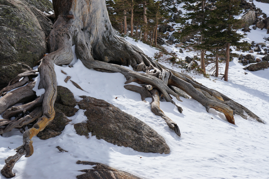
Interesting tree roots.
Another view of Emerald Lake
Windblown Snow
Michael and I made it higher than I had the previous Sunday. This is working our way up a gully above Emerald Lake.
Crossing a rock slide. We turned around not long after this because we felt the terrain got to steep.
The view from our turnaround point between 10,500 and 11,000 feet.
Michael at our turnaround point. Shortly after this, clouds started rolling in and it started snowing. We made the right decision in turning around.
Michael out on the lake.
The view from Moraine Park on our drive out.
We had a great time. I loved both hikes. Now I want to go back and explore the park when I have more time.
I arrived late Friday night and stayed with my brother. We visited Garden of the Gods on Saturday. It must have been 75 degrees, which was a bit of a shock coming from the chilly weather here the previous week. It was crowded, but we managed to find a short trail with only a few people.
On Sunday, a friend and I borrowed snowshoes fand headed for Rocky Mountain National Park. For all of the times I've been to Colorado, I had never actually been there. We were warned that parking can be at a premium at Bear Lake Trailhead, but the lot was only about 1/3 full when we got there. We hiked the trail towards Emerald Lake. I expected to struggle. I arrived 48 hours prior to our hike and my friend arrived had been in Colorado less than 24 hours at that point. The trailhead is at nearly 9,500 feet. Much to my surprise, we did pretty well. We were slow on the uphills, but otherwise, we had a good hike to Emerald Lake. The views were just spectacular. There is a reason why this is such a popular area.
Looking towards Emerald Lake from Nymph Lake
On the hike up to Dream and Emerald Lakes. Although it was relatively warm, the wind was fierce. I wore my parka the entire hike.
Just above Dream Lake.
The bark of an evergreen tree.
Looking down on Emerald Lake
My friend snowshoeing above Emerald Lake. We turned around shortly after this. The legs were strong, but my lungs were burning a bit at this point from the lack of oxygen.
Frozen Emerald Lake
I love this picture for the sense of scale. In addition to the group on the edge of the lake, there are two skiers about halfway up the chute in the top center of the photo, just to the right of the large pillar of rock.
A dead tree on the lakeshore.
Standing on Emerald Lake. I'm pretty sure this is the first time I've been out on a frozen lake. On this day, the ice was really smooth.
Bubbles trapped in the ice.
Our hike back to the parking lot was quick. The parking lot was a complete circus, complete with people clubbing each other for parking spots. We were still feeling energetic, so we decided to hike to Alberta Falls. I sort of expected the frozen columns of ice that one usually sees when waterfalls freeze. What we found instead was an inky black sheet of ice through which we could see water flowing. I had never seen anything like it. It was very cool and completely unexpected. Unfortunately, I couldn't capture it with my camera.
After my week of meetings was over, Michael flew out to Colorado to join me. As I said earlier, we intended to stay with friends for the weekend. That didn't wind up happening because several members of their family got sick. So, Friday, Michael and I borrowed the same snowshoes and I took him up to do the same hike. I know there are a million other places we could have gone, even within the National Park, but I was so impressed with Emerald Lake that I wanted him to see it.
The weather wasn't quite as perfect as it had been five days earlier. There were more clouds and periodic snow flurries, but it also wasn't as windy. This is the view from Dream Lake.
Interesting tree roots.
Another view of Emerald Lake
Windblown Snow
Michael and I made it higher than I had the previous Sunday. This is working our way up a gully above Emerald Lake.
Crossing a rock slide. We turned around not long after this because we felt the terrain got to steep.
The view from our turnaround point between 10,500 and 11,000 feet.
Michael at our turnaround point. Shortly after this, clouds started rolling in and it started snowing. We made the right decision in turning around.
Michael out on the lake.
The view from Moraine Park on our drive out.
We had a great time. I loved both hikes. Now I want to go back and explore the park when I have more time.
Labels:
Colorado,
Emerald Lake,
Rocky Mountain National Park
Subscribe to:
Posts (Atom)