Showing posts with label Monongahela National Forest. Show all posts

Sunday, January 30, 2022

Snowshoeing and Some Thoughts on visiting Dolly Sods in Winter

 I'm going to give this blogging thing a try again. It has been a couple of years...quite a couple of years. But here I am and I'm still outside. I just haven't been writing as much about it. I have been posting on instagram, so it is worth checking that out, too.

We snowshoed up into Dolly Sods today with a friend. We started at the gate on the north side of Forest Road (FR) 75.* There were a couple of inches of snow where we parked. It quickly became 6 inches as we walked up the road. Then after the first mile, it was more like 12 inches. It kept getting deeper all the way up the road until the very top of the plateau. Just below Bear Rocks, the snow was suddenly gone, having been scoured away by the constant wind up there. Wherever there was shelter, there were snow drifts. We made the three miles uphill to Bear Rocks in decent time. Then we spent some time at the cliffs on top of the plateau. It was a pretty magical, perfect weather day:  temperatures in the low 20s and little wind. We had originally intended to hike yesterday, but our friend had a conflict. That turned out to be a good thing: yesterday, the high was about 10 degrees and the winds were gusting over 50 mph. 

We only saw one group the entire day: a group of six that were woefully underprepared for the night they had just spent out. They were in good spirits, at least, and headed out, so they were going to be fine. 

*So, a few thoughts about visiting Dolly Sods in winter because we've encountered a few groups that seemed surprised by these things over the past few years. 

  • Unless you are staying in Old Timberline, there is no way reliable way to drive up to Dolly Sods in winter. The US Forest Service gates both FR 75 and FR19. I don't think FR 80 is gated, but it also isn't plowed. At all. This means that however you go, you will have a long approach walk. It is three miles from where we parked today to Bear Rocks, on the eastern edge of the plateau. It is all uphill to get up there. It isn't super steep, but it is a steady climb. FR 75 absolutely needed an AWD vehicle today just to get to the gate. I've seen several parties pull up to the gate there completely surprised that they couldn't drive up. 
  • Weather: The weather can be really harsh up there. If it is breezy and chilly down in the valley, or where you live, you can bet it is gale force winds and frozen up in Dolly Sods. We were up on the west side of Dolly Sods two weeks ago and it was so windy that it was difficult to stand. I've also been lucky enough to be up there when it is cold but there is little wind. Those days are pretty magical. If it has been warm, it will be a muddy mess up there in the winter. My point of all of this? Hiking in Dolly Sods in winter requires you to be prepared for harsh conditions. 
Pictures:
Michael Snowshoeing up the road
Michael and our friend working their way up the road
Wind scour lines in a snow drift
Looking east from Bear Rocks
Looking out over the valley to the east
Michael near Bear Rocks
North Fork Mountain in the distance
Flagged trees near Bear Rocks
Flagged trees near Bear Rocks.

Tuesday, March 27, 2018

Dolly Sods: Snowshoeing to Bear Rocks

It snowed here last week. It snowed a lot up in the mountains. Given that we hadn't seen enough snow in the last two years to use our snowshoes, we couldn't resist a day trip up to Dolly Sods. Usually, when we go up there, we hike in from the west side, near Timberline Ski Area. This time, I wanted to try something different: hiking to Bear Rocks on the east side of Dolly Sods. It is an extremely popular area in the summer, but winter is a different matter. Access to the east side of the wilderness in winter is challenging: the US Forest Service gates the road three miles below the boundary of Dolly Sods. You can park at the gate as long as you don't block the gate.

The drive up to the gate got interesting once we passed the last driveway. It isn't plowed. All wheel drive or four-while drive is definitely advised. Once parked, we headed up the hill. At first, there wasn't much snow and I was worried we had driven all this way only to get skunked. But, I needn't have worried. Soon enough, the snow was deep enough for snowshoes. We passed one party on their way down. They had spent a long, cold night out and hadn't made it to Bear Rocks. Once we passed their campsite, we were breaking fresh trail. The hike up the road was uneventful. It is just three miles of steady climbing, none of it terrible. We made it to the boundary of Dolly Sods in time for lunch.

After lunch, we set off exploring Bear Rocks and snowshoeing down the road. It was spectacularly beautiful up there and amazingly quiet. I never realize how much background noise we all live with every day until it is absent. The only sound was the wind, which was mercifully light by Dolly Sods standards. The sun was warm and it was a perfect winter day.

 The road up to Dolly Sods
 The boundary of Dolly Sods
 Rabbit tracks in the snow
 A turkey track
 Snowshoes!
 A bobcat track.
 Michael at Bear Rocks
 Looking east from Bear Rocks towards North Fork Mountain. By the time we reached this point, the sky had become a bit hazy.
 Another view from Bear Rocks.
 Icicles on a conifer
 Remnants of snow on a conifer
 Looking west into the wilderness area.
Michael snowshoeing down the road.

Monday, August 29, 2016

Roaring Plains, or We Actually Went Backpacking

We went out to Roaring Plains with a couple of friends two weekends ago. The weather forecast, honestly, wasn't great. There were significant chances for showers both days, so I wasn't sure how it was going to go. Our itinerary was a little up in the air depended on how fast we were able to hike. I was hoping to explore a little bit more than the area where we've been up there. We were also hoping for blueberries. Neither of those things happened, but we still had a really nice trip.

Saturday, we really won the weather lottery. There were scattered clouds and a couple of times it looked like some of them might organized themselves into something more assertive, but it never happened. The temperature was nice and it was mostly sunny. Flowers were blooming everywhere in the bogs and meadows in an end-of-summer bonanza. We did find some blueberries, but only just enough for our morning oatmeal. Many of the blueberries we found were well past their prime. We made pretty good time to the gas line cut. From there the trail (which it technically is, but calling it that is...generous) gets more challenging to follow. When we did this trip two years ago, it took all four of us and two dogs paying attention to keep to the route. It was no different this time, although we only had one dog. Late in the afternoon, we picked a wonderful campsite right on the rim of the plateau with a great view of North Fork Mountain and Seneca Rocks to the southeast.
The path across one of the heath balds. The low shrubs are almost all blueberries.
 Picking blueberries.
The gas line cut through the area. After this the trail gets much more challenging.
Rudebeckia laciniata (Cut-Leaf Coneflower)
 The view from the promontory aptly named, "The Point"
 The same overlook.
 The view from our campsite.
Sunset from our campsite.

Clouds rolled in overnight and we woke up to overcast skies and high winds. The rain held off long enough for us to eat breakfast, but not long enough for us to keep the tent dry while we packed up. We debated which way to go: to continue on the loop or to turn back the way we came. As we were discussing it, the clouds lifted and we spotted some blue sky. We continued on the loop. The section of this trail (again, a term used generously here) between our campsite and where it meets up with the Roaring Plains Trail is probably one of the most rugged trails I've hiked in the mid-Atlantic. Even having hiked this before, we really had to pay attention to stay on the route. Even so, we had to backtrack several times to get back on the right path. By the time we reached the long boulder field that the trail descends, the wind had mostly dried the rocks, which made that section easier. The weather held exactly as long as we needed it to: As soon as we made it to the bottom of the boulder field, it started raining lightly again. We finally made it to the junction with the Roaring Plains Trial just before noon: three hours to go a little over two miles.

We caught another break in the rain for lunch at a nice campsite at the junction. As soon as we began packing up, the rain started again and, this time, with purpose. We took a right on the well-maintained Roaring Plains Trail and our pace tripled. Soon enough, we reached the forest road that we had to hike for a couple of miles back to the car.

It was a great trip. This is one of my favorite areas to hike. I want to get back up there again and do more exploring. I sort of assumed that, since we had hiked the rough section two years ago, that we would move faster on it this time, which was wrong. It is just a hard, slow section of trail to navigate. Lesson learned and we'll do a different route next time if I want to see a different part of the plateau. Another bonus: We didn't see a single other person the entire weekend.
Waking up to gray skies.
Overcast, slightly dreary view before breakfast.
 After the first rain shower moved through, fog rose from the creeks in the valleys.
 Contemplating the boulder field.
 Platanthera ciliaris (Yellow Fringed Orchid). One of the more interesting plants in this area.
Gentiana linearis (Narrow-leaved Gentian). These beautiful little flowers were going off everywhere.

Tuesday, May 5, 2015

North Fork Mountain: 25 Miles of Views

Back in March, we hiked a tiny portion of the North Fork Mountain Trail - just enough to find out that we needed to get back there and hike the full 25 miles of the trail. The same friend that went with us on that hike wanted to go as well and schedules aligned this past weekend. Coming from our area, setting up the car shuttle takes some time. By the time we left a car in the parking lot on Smoke Hole Road on the north end of the trail and drove down to the south trailhead on US Highway 33, we had been on the road for over four hours.

We set off from the southern trailhead just after 10:30. The trail starts at the top of the mountain. In spite of the green and flowers down in the valleys, spring had yet to climb to the very top of the ridge. None of the trees had leaves on them yet and much of the forest was still dormant. There were small signs of spring, though: blooming serviceberry trees and spring beauty carpeting the ground wherever the trail dropped a few feet in elevation.

There are probably good views early in the hike, but the first few miles of the trail pass through private land and there are No Trespassing signs here and there, so we stayed on trail.
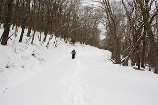
The trail near the southern end of the North Fork Mountain Trail
Goodyera pubescens (Rattlesnake Plantain) leaves. This is an orchid that blooms later in the summer.
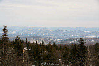
One of many, many great views to the west. The shadows from the clouds made for interesting patterns in the valley below.
An old hang gliding launch.
Pine cones.
Micranthes virginiensis (Early Saxifrage)
Claytonia virginica (Spring Beauty). Wherever the trail dropped a few feet in elevation and had good sun exposure, the early spring wildflowers would appear.
North Fork Mountain is a lot drier than higher areas of Dolly Sods and Roaring Plains, which are across the valley to the northwest. It still gets some impressive winds, though, based on the fact that all of the trees on the edge of the ridge are flagged like these. This is looking to the southwest.
This is back of Seneca Rocks from mile eight. The timing of this picture is a bit unfortunate. The trees haven't completely leafed out, so there isn't a lot of contrast between the rocks and the trees. The back of the rocks are also in the shadow. Morning would be a better time to get a good shot there.
Bootshot from one of the overlooks.
An old barn down in the valley. The fields in the valley looked so green compared to where we were hiking.
 Amelanchier laevis (Allegheny Serviceberry)
Another view to the south from the trail.
An ephemeral pond below the spring near our campsite at mile 12.5. North Fork Mountain is dry. Even though it had rained the week before our trip, we only saw water in two places in the entire 25 miles. More on that at the end of the trip report.
Sunset at our campsite. There is a road, FS 79 that intersects the trail at mile 12.5. We found a camspite near there, but mostly out of sight of the road. We had a great view of the sunset and spent a pleasant night there.

We woke up on Sunday to a clear sky and the promise of a hot (for May) day. After breakfast, we continued north. We immediately ran into a group of 19 high school students and their teachers doing the trail in the opposite direction. They were the only people we would see on Sunday until the very end of the trip, when we saw two dayhikers.
The first part of Sunday's hike led us through a lot of areas that had been burned, some of it severely. The trees at our campsite showed fire damage, but the fire clearly burned hotter in areas like the one above.
Most of the many views on the trip are to the west. This was a rare view to the east.
A cool erosion feature, about the size of my fist, in a rock along the trail.
The view from the campsite near the Redman Run Trail
Uvularia puberula (Mountain Bellwort). The trail was generally a few hundred feet lower on the second day and we started seeing a greater variety of wildflowers.
The home stretch: Looking north towards Chimney Top (the high point in the band of cliffs). At this point, we had less than four miles to go to the car.
 The benchmark on at the summit of Chimney Top
Looking down at one of the spires of Chimney Top.
 The view to the south - from where we'd come.
From Chimney Top, we hiked the three steep miles down to the car. At some point, Michael and I realized that the trees had leaves on them and everything was green. We had hiked from late winter back into early spring.
Dodecatheon meadia (Eastern Shooting Star). I've seen the western variety of this cool little flower several times, but I'd never seen the eastern species. We ran into them near the trailhead, which was a nice way to finish the hike.

This hike is amazing. We would definitely do it again. The views are non-stop and incredible. I can only imagine what it must look like during fall leaf change. It isn't remotely crowded. Other than the group of high school kids, we saw three other hikers and six mountain bikers in two groups. 

Water is an issue, though. The spring at mile 12.5 had several inches of water in it, but it is May. I don't know how much would be there in, say, September. The pond below it definitely dries up. The only other place we saw water was in large truck ruts around mile 11. They wouldn't be my first choice of water sources, but in a pinch, with a filter, they would work. Of course, they dry up as well. FS 79 is passable to regular cars, so caching water near the campsites at mile 12.5 probably makes the most sense if there aren't recent reports of water in the spring or if it has been dry.