Showing posts with label Massanutten Trail. Show all posts

Sunday, March 13, 2022

Signal Knob the Day After A Spring Snowstorm

 Yesterday, we had a spring storm that started out with gross, cold rain. It quickly changed over to snow. It didn't amount to much in the DC area and, even in the mountains, it wasn't expected to be more than a couple of inches. That meant snowshoeing was out. This weekend is also time change, which meant that we would have to drag ourselves out of bed earlier than usual, too. We ultimately decided to do a hike we hadn't done in several years: Signal Knob. The hike starts in a large parking lot that often fills near Elizabeth Furnace in the Massanutten area. 

When we pulled in, there was one other car in the parking lot. Not a bad start. It was 16 degrees with the promise of temperatures rising to near 40. The trail was covered with an inch or two of snow and the steady climb was a welcome way to warm cold fingers. There were a few tracks on the trail, which ended at the first campsite. Someone had clearly been up either camping or just enjoying a campfire the night before. It would have been chilly night to be out! After that, we were the first people on the trail today. We saw and heard our first Pine Warblers of the year, which was a welcome sign that spring is coming! 

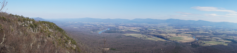
At Signal Knob, we found a relatively sheltered spot to eat some lunch. There was more of a breeze that was ideal and it was still pretty cold. At this point, we were kind of marveling that we hadn't seen anyone so far. When we've done this hike, in the past, we've backtracked from Signal Knob to the Meneka Peak Trail and hiked south on that to catch the Tuscarora. This time, we decided to continue on the Massanutten Trail and connect with the Tuscarora in the valley below to the west. While this meant an extra climb, the distance was the same and it kept us out of the wind on the ridge. The hike down to the Tuscarora Trail went quickly on the road. From there it is steep climb back up to the top of the ridge. We quickly shed the layers we had put on at lunch.

From the junction with the Meneka Peak Trail back to the car is four winding miles. By this time, most of the snow had melted off of the trail and there were definitely some muddy patches. It was a pleasant walk down, though and we saw no one until we reached the parking lot. It was a really good day. All said and done, 10 miles.

The view northwest from Signal Knob
Leaves frozen into the ice on the Massanutten Trail near the junction with the Tuscarora
A relatively poor photo of a lenticular cloud west of us. I forgot the battery for my good camera, so all I had was my cell phone.
Bird tracks in the snow
The Tuscarora Trail below Meneka Peak
Perfect blue sky
A bird nest from last year. It looks like it might be a Red-Eye Vireo nest.


Saturday, February 12, 2022

Hike to Emerald Pond

 We did the Emerald Pond hike in the Massanutten area today. It is a little over 8 miles and is a lollipop, so there is a little loop at the end, but there's some out-and-back as well. The hike starts from the abandoned Massanutten Visitor Center on Highway 211. I couldn't find any reference online as to when it closed. There is an article in the Washington Post from 1989 that references it being open, but other than that, there is little information on it. 

In any case, after a short descent, the trail climbs steeply for a bit more than a mile to a really nice overlook of the Shenandoah Valley to the west. We took a brief break there and then continued south on the Bird Knob/Massanutten Trail. From the overlook, there is probably another two miles of very gentle climbing and then a slow descent towards Bird Knob. About a mile after the overlook, the Massanutten Trail splits off to the left. We stayed on the Bird Knob Trail. The trail passed through lots of pine groves and mountain laurel, nice and green in the middle of winter. We came out into a meadow with a tiny frozen pond at the end of the Bird Knob Trail. From there, we descended to Emerald pond, which is, indeed, clear and and green. After a bit of confusion about which way to go, we headed up the hill to the Massanutten Trail, which follows a forest road for a few miles. We passed a lot of large Allegheny Mound Ant mounds, but I neglected to take pictures of them. At the junction with Bird Knob, we retraced our steps to the car.

A White Breasted Nuthatch near the overlook. 
The Shenandoah Valley from the Overlook
The tiny frozen pond
Emerald Pond
The overlook on our way down.


Thursday, March 15, 2018

Stricklers Knob

Saturday, Michael and I finally got out after what seemed like months of rain only on the weekends (ok, maybe a month of rainy weekends). I don't mind hiking in the rain in the summer, but I'm not a big fan of cold rain. We intended to do the Stricklers Knob-Duncan Knob loop, which is about 10 miles. Michael had never done it before and it has been a number of years since I've been on those trails. We arrived to find the road gated about three miles before the Scothorn trailhead. We talked for a few minutes about driving to Kennedy Peak, but we weren't really interested in spending more time in the car. After consulting the map, we could walk up the road 3/4 of a mile and pick up the Massanutten Trail. From there, we would be able to hike to Stricklers Knob. Once there, we could decide whether to return the way we came or hike straight down the mountain and walk back on the road.
 The trail started out with a pretty walk along the ridgetop. Once we turned a corner, we could see Strickler's Knob and it was right there across the hollow beside us below. Unfortunately, we had to descend very steeply all the way down to the bottom of that valley and then hike back up it before we would get there. All the way down into the valley we listened to someone's hunting dogs baying.
 A campsite on the Massanutten Trail at the bottom of the valley.
Four miles later, we made it to Scothorn Gap and were well on our way to Stricklers Knob. The trail passes through a fire scar.
 The trail out to Stricklers Knob turns into a rock scramble for the last two hundred yards or so. A pair of black vultures were fairly annoyed to be disturbed by us. They would flap their wings and fly a few yards away, only to land directly in the next spot we were hiking to.
 A closer view of one of the vultures (I have a decent zoom lens). They finally flew off and we proceeded out to the knob.
 The view east from Stricklers Knob.
 There is another cliff just northeast of Stricklers Knob that actually has a bit better view. I took this panorama from there. That is the Shenandoah River in middle of the photo.
 The cairn marking the path out to Stricklers Knob. At this point, we decided we didn't need to see the bottom of that valley again, so we hiked down the Scothorn Gap Trail to the road.
 We had a pleasant three mile road walk back  to the car.

The temperature was nearly 50 degrees, which was a nice change from our string of rainy, cold weekends.


Thursday, February 5, 2015

Signal Knob and Three Top Mountain

We hiked Signal Knob and Three Top Mountain in the Massanutten area this past Saturday with two friends and their two border collies. We've hiked Signal Knob a number of times before, but this time, we approached it from the back (southwest). We met our friends in Front Royal and piled into their car because it has all wheel drive. I had a feeling the road to the trailhead wouldn't be in great shape, which turned out to be the case. Most of the last couple of miles of the road were covered in snow and ice.

The first half of the hike follows a fire road except for a brief stretch of trail that goes around Strasburg Reservoir. It is a pleasant walk, generally uphills, but nothing too steep until the approach to Signal Knob. Like I said, we've hiked up to Signal Knob before from the Fort Valley Side. At the top of the mountain, there is a communications tower and a power line cut with a nice view towards Front Royal to the northeast. We had always stopped at the power line cut and usually would have lunch there. Then we would return the way we came for the hike back. I had no idea there was another viewpoint a few hundred yards north of the power line cut with a view to the west towards Strasburg and Great North Mountain. I had just never walked beyond the communications tower. Since we came up the mountain the other way, we found it this time (and our friends knew about it).

We went back down Signal Knob the way we came to the junction with the Tuscarora Trail, where we turned right and headed up to the top of Three Top Mountain. After climbing gradually towards the ridge, the trail follows the top of the ridgeline for a couple of miles. The ridge walk was really pretty. It is a narrow ridgeline with upturned rocks and views through the trees both east and west (the views are probably best in the winter). When we reached the junction with the Massanutten Trail, we turned downhill and made a quick descent down to the road and the car.

It was a nice hike, but there is a fair amount of road walking, which would be less pleasant on a blazing summer day. Three Top Mountain is really pretty. We had perfect winter weather: 30s and sunny.
Our friend and Michael walking up the road near the beginning of the hike.
Strasburg Reservoir from the dam.
Our friend's very dignified border collie on top of Signal Knob.
The view from the power line cut towards Front Royal.
The overlook I had missed several times before: northwest from Signal Knob
Cool ice patterns.
Moss in the snow.
The sun shining on snow on Three Top Mountain.
This tree broke in nearly a perfect square when it fell over.

Tuesday, April 29, 2014

Browns Hollow Loop: Flowers and Waterfalls

Michael, a friend, and I took a break from cycling this weekend to get out for a nice, long hike. We went out to the south part of Massanutten Mountain in the George Washington National Forest. It was an absolutely beautiful day. We started seeing early spring wildflowers right away. The hike started at the erstwhile Massanutten Visitor Center. We followed an old nature trail down to the Browns Hollow Trail, which slowly climbed up to a saddle between Short Horse Mountain and Big Mountain. Along the way, we saw several very nice waterfalls. We had lunch at the foot of one that was nearly 20 feet high. Since the trail was quite a ways above the creek, it was an interesting scramble down to the falls.

After reaching the top of the saddle, we then lost nearly all of the elevation we gained, only to have to re-climb it on the Roaring Brook Trail. Several steep switchbacks put us on top of Big Mountain, where we had views through the trees. The we descended to the bottom of the next valley to the Massanutten Trail. The Massanutten Trail follows a gravel road in that section. No shade and a steady climb made for a surprisingly warm climb for a spring day. Since it was April, it was pleasant, but it would be a miserable climb in July or August because of the lack of shade.

Eventually, the trail returned to the woods and we were rewarded with a beautiful overlook to the west, only about 1.5 miles from the car. We noted the fact that, in spite of the proximity to the road, there was very little trash and no graffiti. When we finally left the overlook and continued on our way, we found out why. It is, indeed, only about 1.5 miles from the road, but it is a tough, steep, rocky climb. We didn't mind, since we only had to hike down it.

Massanutten is one of the unnoticed areas to hike around here. We saw one group of backpackers and one lone hiker. It was a really pleasant hike that I definitely would do again.
These Viola pedata (Birds Foot Violets) were right along the trail.
We startled an Eastern Fence Lizard (Sceloporus undulatus). Eastern Fence Lizards blend in with tree bark really well. Click to enlarge.
 A fiddlehead along the trail.
This is the 20-foot waterfall, although it doesn't look like it in this picture. It was tough to get an angle that showed the scale.
 A butterfly (I don't know the species) on Mountain Laurel on top of Big Mountain.
The Massanutten Trail follows this gravel road for a few miles. At this point, we were fairly high, so the trees hadn't begun to leaf out. Everything is several weeks behind where it has been in the last few years. I've been out this time of year and the entire canopy had grown in, but this year, it was basically still winter up here.
 The craziest thing we saw along the trail were these massive ant hills. You can see my hiking pole in the bottom of the photo for a little bit of scale. This thing was easily four or five feet in diameter and two feet high. There were ants everywhere.
 A close-up of the ants (you'll have to enlarge the picture to see all of the ants).
 A bootshot from the overlook. This is looking west towards Great North Mountain.
 Michael at the overlook.
 Uvularia puberla (Mountain Bellwort). This one was a new species to me.
Allium tricoccum (Ramps). We saw these along the way as well, which was a big surprise, since I generally associate them with higher elevations. Any guesses? I'll post the answer later this week.

Monday, October 22, 2012

Leaves: A Beautiful Hike of Kennedy Peak

Sunday was a perfect fall day for hiking:  crisp, dry, and clear.  We decided to try a new hike in the Massanutten area of the George Washington National Forest:  Kennedy Peak.  Massanutten is the overlooked little sister to Shenandoah National Park (which is just fine with me).  It is made up of the two steep ridges to the west of Shenandoah.  There are a few hikes close to Front Royal that see some traffic, particularly Signal Knob and the Elizabeth Furnace area is popular with both mountain bikers and climbers, but even those don't see a fraction of the number of people that somewhere like Old Rag does, let alone Skyline Drive.  The hikes are quiet and every bit as interesting and scenic as those in Mansanutten's better known neighbor to the east.

Kennedy Peak is no exception to that.  We started off at a parking lot just below Edith Gap.  The fall colors were definitely peaking.  Everywhere the sun hit, yellow and red leaves glowed against the sky.  The hike started on the Massanutten Trail, with a well-switchbacked climb up to the gap and then followed the ridgeline north a couple of miles to the Kennedy Peak Trail.  We didn't really make good time because there were so many pretty trees to look at and to photograph.  We did startle several several Pileated Woodpeckers along the way.  The little tower on top of Kennedy Peak made a perfect stop for lunch as turkey vultures soared above us, riding thermals over the mountains.  From there we returned to the Massanutten Trail and hiked another mile north to the Stanley Trail, where we began to work our way back to the car.  At one point we stopped briefly to take more pictures and a raptor began to fly back and forth shrieking.  Since it was pretty high above us, I don't know if it was because of us, but it was fascinating to watch.  

At the end of a fabulous day, we had walked 9.2 miles and seen a total of four other hikers.  

Pictures (click to enlarge):
 Bright red maple leaves.
 The Massanutten trailhead at Edith Gap
 A yellow maple leaf.
 A large spider on the Kennedy Peak Trail.  I think it is a Wolf Spider.  It was about 3 inches across.
 Michael taking a break after lunch on the tower on top of Kennedy Peak.
 Symphyotrichum sp. (Aster).
 Looking northeast towards Shenandoah and Front Royal
An interesting moth that appeared to be laying eggs.  If anyone knows the species, let me know and I'll post it.  Thanks to Old Rag Patrols for figuring out that this is a Buck Moth.
 Walking north on the Massanutten Trail.
 Hamamelis virginiana (Witch Hazel) - the very last flower to bloom in the fall and a sure sign of the coming winter.
 Looking back toward Kennedy Peak on the Stanley Trail.
More beautiful foliage.