The Thursday holiday gave several of us the opportunity to hike mid-week, something we don't get to do very often. It promised to be one of those rare, brilliantly sunny, perfect fall days and we were lucky enough not to be trapped in the office. By the time we arrived at the trailhead, it was a little cool, but warm enough to start in short sleeves. The Scotthorn Gap Trail climbs steeply up from Crisman Hollow road for almost a mile and a half before meeting the Mansanutten Trail. We were surprised that there were still so many leaves on the trees. Since I had not been hiking in two weeks, I expected most of them to have dropped.
Once on the Mansanutten Trail, we quickly reached the top of the ridge. We took a short break and then looked for the semi-official trail to the top of Strickler's Knob. There were no blazes at the junction of the footpath with the Mansanutten Trail, but the path was obvious enough. Soon, pink or maroon blazes appeared on rocks along the path. The path was really rocky and as we got closer to the end, it turned into a rock scramble. Our friend's dog, Sammie, had to be helped over several of the spots, but otherwise handled it very well. Strickler's Knob provided a perfect lunch spot with a great view. Since it was bright and sunny, it was actually warm enough to sit, enjoy the good weather, and watch turkey vultures ride the thermals.
After lunch, we returned to the Mansanutten Trail and made our way downhill into Duncan Hollow. The trail, after a few switchbacks, flattens out into a very gentle downhill. We made good time to the junction with the Gap Run Trail. The Gap Run Trail was the steepest section of the hike. We climbed almost 900 feet in three-quarters of a mile. One of the challenges in the Mansanutten area is that the trail is often covered in rocks sized perfectly for tripping or for rolling an ankle (on some trails, one would think the word, "Mansanutten" is an old Indian word for "really rocky trails"). The Gap Run Trail is no exception and with most of the leaves having fallen from the trees, there was the extra bonus of not being able to actually see the rocks.
The trail ends up at the top of Peach Orchard Gap, where a trail splits off leading to the top of Duncan Knob. We took a quick break and headed up to the knob, which involved another rock scramble. Sammie sat this one out. The view from the top of the knob was incredible. Although it was only 2:30 p.m., the sun was already low in the sky, which brought out the red leaves still on the trees in the valley. We still had a ways to hike, so we didn't linger. We rejoined Sammie and returned to the Gap Run Trail and headed downhill to the Scotthorn Gap Trail.
From there, it was an easy walk back to the junction with the Mansanutten Trail. This time, we turned downhill, passing a small pond that none of us had noticed on the way up the hill, and returned to the car. It was just starting to get cold as we ended the day.
Pictures (click to enlarge):
Sammie looking out over the valley near Strickler's Knob.
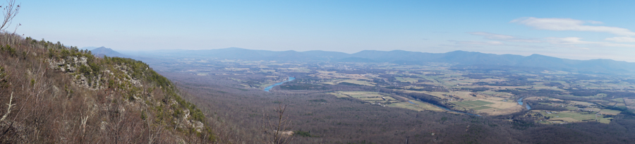
The view south of Stickler's Knob.
A snakeskin on the Mansanutten Trail. The pieces were over four feet long altogether.
Maple leaves.
The scramble up to the top of Duncan Knob.
Bootshot from the top of Duncan Knob.
The view west from Duncan Knob.
Aster sp. (Asters) on the Gap Run Trail.
The Scotthorn Gap Trail in the late afternoon sun.